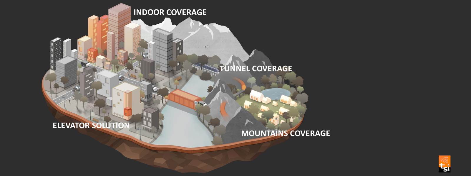
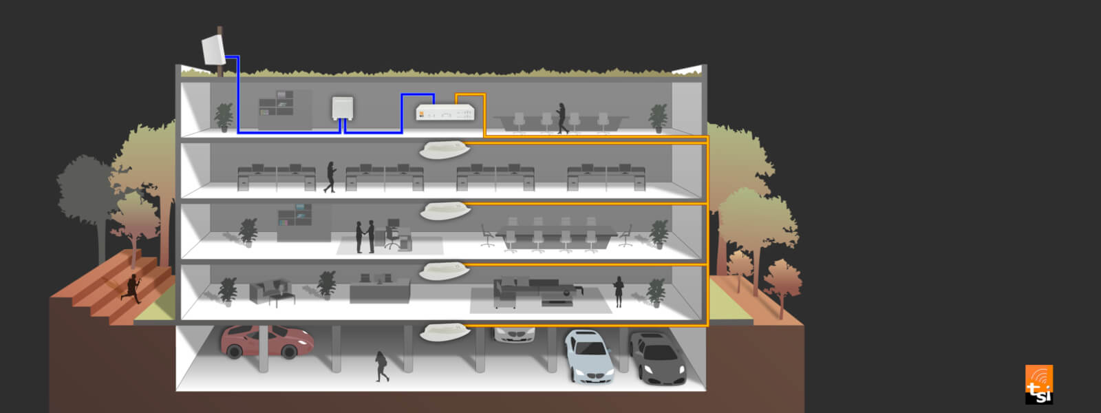
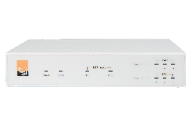
|
|
The
GPS Demo software GpsView doesn’t seem to be making any connections
with my Bluetooth GPS receiver. How do I make it work? (i-Blue7x7
Series) |
| |
You
will need to make sure your PDA is paired with Bluetooth device. Follow
the section “Chapter 2. Getting started > Step 3 Connecting
your handheld device with the i-Blue” to make sure that your
PDA is recognizing the Bluetooth GPS receiver properly. If so, you
will need to connect with the device by going to the Bluetooth Manager
and double-tapping on the i-Blue icon. |
| |
|
|
|
My
Bluetooth GPS Receiver seems to be receiving the satellite signals,
but I am unable to establish a connection between the receiver and
my PDA. How can I make a connection?(i-Blu7x7 Seriese) |
| |
Go
to the Bluetooth Manager on your PDA. Locate the “i-Blue: SPP
Slave” icon and tap and hold. A pop-up menu will appear, select
Delete. Next, perform a soft reset on your PDA. Once your PDA has
finished resetting itself, go back to the Bluetooth Manager screen
and perform the typical setup and connection procedures for your Bluetooth
receiver (for help with connection please review the section “Chapter
2 Getting started > Step 3 Connecting your handheld device with
the i-Blue”). |
| |
|
|
|
Does
the i-Blue Bluetooth GPS receiver work with my smart phone and TomTom
Mobile Navigation software?(i-Blue7x7 Series) |
| |
Yes.
We found that TomTom Mobile Navigation tool recognize the device name
“GPS”, which is capital sensitive. If the default name
of your receiver does not include the word GPS, you have to rename
your device, for example xxxxGPS. |
| |
|
|
|
How
can I connect a smart phone with a i-Blue GPS receiver?(i-Blue7x7
Series) |
| |
We
provide a series of common procedure of software installation to set
up your SmartPhone, and they are OS oriented. For some unique OS,
the steps may be a little bitdifferent, please see your phone’s
manual.
(SOP
for Windows Mobile 2003)
(SOP
for Symbian Series 60) |
| |
|
|
|
Where
can I buy a brand-new battery for i-Blue usage if I want another one?(i-Blue7x7
Series) |
| |
i-Blue's
battery is compatible with lots of digital cameras' bettery. A new
battery is very easy to get. i-Blue
Battery Info
Also, i-Blue7x7 Series is compatible with lots
of Nokia cellphone's bettery (Original Nokia Li-ion Battery BL-5C),
Compatability:
1100, 1101, 1110, 1112, 1600, 2300, 2310, 2600, 2610, 3100, 3120,
3650, 3660, 6030, 6230, 6230i, 6270, 6600, 6630, 6670, 6680, 6681,
6820, 6822, 7600, 7610, E50, E60, N-Gage, N70, N71, N72, N91 |
| |
|
|
|
What's
the default baud rate for i-Blue7x7 series? (i-Blue7x7 series) |
| |
The default baud
rate for i-Blue7x7 series is 115200 bps. |
|
|
|
|
Is
it possible to enable the VTG/ GLL NMEA sentence in i-Blue7x7 series?
(i-Blue7x7 series) |
| |
No, default setting of i-Blue7x7 supports following NMEA protocol:
GSA, GSV, RMC, GGA |
|
|
|
|
Where
can I find another home charger for my GPS? (i-Blue7x7 series) |
| |
To charge your i-Blue7x7, you can use any home
charger which supports DC output range from 4.5~5.5V or you can connect
your i-Blue7x7 to laptop via a USB to mini USB cable. It takes 3~4
hrs to fully charge i-Blue7x7. This will neither damage your laptop
nor the GPS. |
| |
|
|
|
I
am installing my GPS now. I have a PDA/ Smartphone, an i-Blue 7x7
and navigation AP. How can I begin to use? (i-Blue7x7 series) |
| |
Please refer to “Chapter 2 Getting started”
from manual. |
| |
|
|
|
Does
i-Blue737 support RTCM? (i-Blue737) |
| |
No, i-Blue737 does not support RTCM. |
| |
|
|
|
Does
i-Blue737 compatible with Palm OS based devices? (i-Blue737) |
| |
Yes, i-Blue737 supports Palm OS based devices.
Caution: Some host devices may not support sniff
mode. In this case, the operation time will become shorter. |
| |
|
|
|
Does
my GPS support SBAS? (i-Blue7x7 series) |
| |
Yes, i-Blue7x7 supports SBAS (WAAS/ EGNOS/ MSAS).
For example, NMEA data below in red shows the information about SBAS.
In this case, i-Blue7x7 uses
the assistant system MSAS (PRN#129). Meanwhile, if in Europe users
may see EGNOS (PRN#120/ PRN#131) from GPS NMEA output.
$GPGGA,091016.406,2446.2993,N,12101.0471,E,2,10,00.8,144.6,M,19.4,M,,0129*6E
$GPGSA,A,3,02,04,06,07,08,10,18,21,26,29,,,1.4,0.8,1.1*34
$GPGSV,3,1,12,2,35,128,39,4,07,132,27,6,33,273,38,7,35,223,38*79
$GPGSV,3,2,12,8,18,055,35,9,14,184,23,10,42,037,40,18,06,281,28*75
$GPGSV,3,3,12,21,13,318,34,26,78,295,42,29,73,355,39,129,54,139,35*45
$GPRMC,091016.406,A,2446.2993,N,12101.0471,E,0.00,123.69,010306,,,D*69
$GPVTG,123.69,T,,,0.00,N,0.00,K,D*7A
|
| |
|
|
|
What
is Fuzzy Auto On/ Off Mechanism and Smart Power Save? (i-Blue7x7 series) |
| |
Fuzzy Auto On/ Off---GPS goes into sleep mode
when Bluetooth is disconnected for more than 3 minutes. When Bluetooth
is connected again, GPS signal reception is ON again.
Smart Power Save---Bluetooth is ON only when NMEA transmission is
required. Bluetooth is OFF when NMEA transmission is not required.
Note: TSI patent pending for “Fuzzy Auto
On/ Off Mechanism” and “Smart Power Save”. |
| |
|
|
|
How
does i-Blue737 perform at low speed? (i-Blue737) |
| |
Some GPS do not update heading at speed below
5 mph, especially used for walking/ hiking (speeds approx 3 mph).
i-Blue737 has following improvement: 1. Improved multi-path performance
at walking speed.2. No heading drift at low speed.3. No position frozen
and velocity accuracy problem. |
| |
|
|
|
What
is the difference between i-Blue737 and i-Blue737 5Hz edition. (i-Blue737
5Hz) |
| |
i-Blue737 5HZ updates GPS NMEA output 5 times
per second, whereas i-Blue737 updates GPS NMEA output once per second.
Caution: Not all navigation tools can take advantage
of 5Hz refresh rates. If the navigation tool does not support 5Hz
option, then the position update is still once per second on the software
side. |
| |
|
|
|
What's
the difference between NAV and LOG mode of i-Blue747? (i-Blue747) |
| |
NAV--- Both navigation and logging functions are
enabled. But when the Bluetooth connection is cut off, i-Blue747 will
stop logging. When BT re-connect, logging is ON again.
LOG--- In this mode i-Blue747 works as a pure logger, no navigation
function is supported. |
| |
|
|
|
What's
the difference between NAV and LOG of i-Blue757 Pro? (i-Blue757 Pro) |
| |
NAV--- Only navigation function is enabled.
LOG--- Both navigation and logging functions are enabled. |
| |
|
|
|
Are
the “Smart Power Save” and “Fuzzy Auto On/Off”
mechanism still available for i-Blue747? (i-Blue747) |
| |
Yes, both “Smart Power Save” and “Fuzzy
Auto On/Off” mechanism are still available for i-Blue747. |
| |
|
|
|
What
does the parameter “Mili-second” mean in LogTool? (i-Blue747/
757 Pro) |
| |
Mili-second is 1 /1000 of a second. |
| |
|
|
|
What's
the default baud rate of iGPS-M Pro? (iGPS-M Pro) |
| |
The default baud rate of iGPS-M Pro is 9600 bps. |
| |
|
|
|
Is
it possible to change baud rate to 4800bps? (iGPS-M Pro) |
| |
The default baud rate for iGPS-M Pro is 9600 bps.
Change baud rate to 4800bps is at the risk of getting incorrect GPS
position data due to bandwidth issue. iGPS-M Pro enables 6 NMEA sentences
that requires 9600 bps baud rate. |
| |
|
|
|
Is
LogTool compatible with MS Vista? (i-Blue747/ 757 Pro) |
| |
Yes, LogTool v2.0 can support MS Vista. |
| |
|
|
|
What
is the limit of expected erase/re-write cycles in logger? (i-Blue747/
757 Pro) |
| |
Users can operate i-Blue747/ 757 Pro well within
100,000 times erase/re-write cycles. Beyond 100,000 times of erase/re-write,
Serial Flash may malfunction. |
| |
|
|
|
Can
users download the logged data by Bluetooth? (i-Blue747/ 757 Pro) |
| |
No, download logged data via Bluetooth is not
supported. |
| |
|
|
|
What
is the difference between “Height” and "Elevation"
in LogTool? (i-Blue747/ 757 Pro) |
| |
ELEVATION--- The elevation of the satellite
HEIGHT--- The altitude of a place above sea level.Besides, ELEVATION,
AZIMUTH and SNR can only be checked when SID (satellite ID) is checked. |
| |
|
|
|
The
latitude and longitude format seems strange in LogTool. Is it a correct
latitude and longitude? (i-Blue747/ 757 Pro) |
| |
Referring to Lat/ Lon format, we don't use "-"
(minus) to show West Longitude and South Latitude. Users can see from
grid array of "Data Log List”, there is an extension field
named "N/S" and "E/W" by the side of "Lat"
and "Lon". |
| |
|
|
|
The
time is not synchronized to my time zone, why? (i-Blue747/ 757 Pro) |
| |
LogTool does give an correct time zone.There are
three places you can see TIME information,
| i. |
Satellite information: local time---
With a real-time display, the local time of your time zone is
shown here. |
| ii. |
Data log list (Grid array): UTC time/ Greenwich time---
UTC time is shown here, not a real-time display. |
| iii. |
GoogleMap: UTC time/ Greenwich time---
UTC time is shown here, not a real-time display. |
|
| |
|
|
|
How
do I know if memory is full? (i-Blue747/ 757 Pro) |
| |
Your memory is full when the orange GPS light
turns from orange to solid blue. |
| |
|
|
|
How
does the mixed logging function work? |
| |
Please see the "Data Log List" of DataLog,
there is a field named RCR (Record Reason).
T--- Stands for “Time Interval”
D--- Stands for “Distance”
S--- Stands for “Speed”
Please see from the grid array of Data Log List to know by which record
method these logged data are recorded. |
| |
|
|
|
How
can I make the internal clock time correct? (i-Blue747/ 757 Pro) |
| |
There are no internal clock delay, it is UTC time
(Greenwich time) that confused users. For local time, users can see
from "Satellite Information" tab, it shows local time and
date.
PS. Local time stands for TIME in which time zone users are located. |
| |
|
|
|
What
height value is recorded in i-Blue747/ i-Blue757 Pro? (i-Blue747/
757 Pro) |
| |
The GGA-sentence in NMEA looks like following
(from “Satellite Information” tab):
$GPGGA,190844.000,4735.5878,N,00739.2819,E,1,5,2.03,298.0,M,48.0,M,,*5F
The height above sea level is 298.0 meters and the height of geoid
above WGS84 is 48.0 meters.
We add these two parameters together (345.937)
and put into logged data. Therefore in the logged data, users can
only see following GGA sentence.
$GPGGA,190844.000,4735.587800,N,739.281880,E,1,5,2.30,345.937,M,0.0,M,0.0,0*78
|
| |
|
|
|
The
*.csv file seems strange, all longitudes are pure numbers, why? (i-Blue747/
757 Pro) |
| |
The field “Longitudes” take advantage
of GPS signal, and the GPS NMEA sentences provide pure numbers.For
example, 120.479725 E---To obtain degree/ minute/ second information,
users can calculate to translate.
i. Degree: 120
ii. Minute: 0.479725*60 = 28.7835
iii. Second: 0.7835*60 = 47.01
Besides, users can set the format in GoogleEarth by themselves, no
matter they want to see pure numbers or format with degree/ min/ sec. |
| |
|
|
|
How
to start a new track log with i-Blue747/ 757 Pro? (i-Blue747/ 757
Pro) |
| |
Please erase previous recorded data first, and
users can start a new track log. |
| |
|
|
|
Does
the solar panel of i-Blue757 Pro charging the device all the time? |
| |
Yes, the solar panel is charging all the time
no matter power switch of i-Blue757 Pro is on or not. |
| |
|
|
|
Will
the trip recorder work with Mac OSX or PPC Macs? (i-Blue747) |
| |
No, our LogTool software only support Windows
2000/XP/Server 2003/Vista. |
| |
|
|
|
Is
there any new version of firmware for i-Blue 747 to set the frequency
to 5 Hz? (i-Blue747) |
| |
i-Blue747 is designed for 1Hz update rate. It
doesn't support for 5Hz update rate. |
| |
|
|
|
Why
I have to adjust the logged data for Daylight Saving Time? (i-Blue747) |
| |
This is because people have already CHANGED their
clocks. Due to original GPS signal shows Greenwitch time, users have
to adjust time back again. For example, day light saving time +2hr.
In case it's 6 o'clock, then you've changed the clock to tell yourself
it's 8. Fact, it's still 6 o'clock. |
| |
|
|
|
How
could I set a correct time and why I always got a clock time shift?
(i-Blue747) |
| |
This is because the logged data stored in logger
is UTC time. For example, if you live in area Greenwich Mean Time
-4. Seeing 19:16:28 in logged data list, your local time is 15:16:28
instead. |
| |
|
|
|
Can
your product be used on 64bit Vista? (i-Blue747) |
| |
Yes, the USB drivers for our products support
64bit Vista. |
| |
|
|
|
As
I can see from LogTool, what does the words mean in the "VALID"
column ? Are there other descriptions apart from "SPS" and
"DGPS"? (i-Blue747) |
| |
As you can see from VALID column, SPS means logged data is recorded
in "GPS fix" situation (also known as Standard Positioning
Service). DGPS means "EGNOS/WAAS fix", known as Differential
GPS.
Yes, there are other 7 FIX QUALITY apart from "SPS" and
"No fix", they are Invalid (no fix), PPS fix, Real Time
Kinematic, Float RTK, Estimated mode, Manual input mode, Simulation
mode.
|
| |
|
|
|
I
have incorrect logged data, how can I make the Logger work again?
(i-Blue747) |
| |
We suggest to perform a ERASE, or a RESET.
| - |
A RESET command wipes out the data in GPS and
return the unit to its initial factory settings. If users having
trouble with their unit and erase doesn't help, a reset may
be recourse. |
| - |
An ERASE command is a way only to erase all the data in GPS's
memory. |
|
| |
|
|
|
What
is the real benefit of 5Hz products? (i-Blue737 5Hz) |
| |
A 5Hz product is extremely for car racing application. 5Hz GPS
can generate more smooth route.
|
| |
|
|
|
How
can I activate the SBAS function? Do I need to turn it on or software
is needed? (i-Blue7x7 Series) |
| |
Our GPS supports SBAS (DGPS) at all times, users
don't have to enable it themselves.
It depends on where users are located, can see or cannot see DGPS
satellite.
Most of the case, in a open sky view users can obtain DGPS signal. |
| |
|
|
|
I
live in Japan, the MSAS ID(PRN) should be "129" for MTSAT-1R
and "137" for MTSAT-2. Why can't I see them? (i-Blue747) |
| |
For Our GPS solution, real output is satellite # - 87
In case it's DGPS satellite #129, users will then see #42
In case it's DGPS satellite #137, users will then see #50
|
| |
|